Verapaces and Semuc Champey
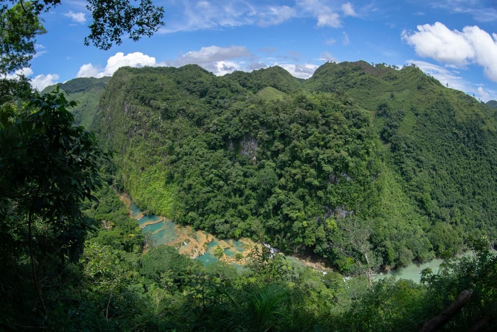
In central Guatemala, a humid karst region where the Cahabón River disappears beneath the limestone bridge of Semuc Champey and forms seven turquoise pools.
The Verapaces is the part of Guatemala that most standard itineraries avoid—and that's precisely why we love bringing our travelers here. The department of Alta Verapaz and its neighbor Baja Verapaz form a band of karst mountains in the north-central part of the country, wedged between the Mayan highlands to the south and the Petén lowlands to the north. Altitude ranges from 300 to 2,000 meters, the terrain is broken and rugged, covered in humid forests that trap clouds nearly year-round. It's easy to understand why the Spanish took more than a century to subdue the region: they eventually entrusted it to the Dominicans, who renamed it Verapaz, 'true peace,' after failing to conquer it by force of arms.
Cobán, the capital of Alta Verapaz, serves as the logistical hub. It's a city of 80,000 people with little particular charm, but it's where the coffee and cardamom fincas concentrate—two crops that sustain the region's economy. Guatemala is the world's leading cardamom exporter, and most of it comes from here. The high-altitude coffee from the Verapaces, grown around 1,300 meters, has a pronounced acidity that we have our travelers taste at fincas in the Chicoj valley or at Santa Margarita in the heart of Cobán.
The population is overwhelmingly Mayan Q'eqchi' and Poqomchi'. At Tactic, in San Cristóbal Verapaz, or at Cobán's Saturday market, you hear these languages far more than Spanish. Women still wear the locally embroidered huipil, different from those of the highlands: white base with red and black geometric motifs. Cobán's patron saint festival in late July, the Rabin Ajau, crowns the young Mayan woman who will represent the country's indigenous culture for a year—one of the rare moments when the city truly comes alive.
The site that brings most travelers to the region is Semuc Champey, 1.5 hours down a very rough track from the village of Lanquín. It's a natural limestone bridge 300 meters long, beneath which the powerful Cahabón River disappears, while on the surface seven turquoise pools cascade across the rock. You swim in them, climb to El Mirador viewpoint (a steep 45-minute ascent) for the full panorama, and often continue to the K'anba caves nearby, which you traverse by swimming with candle in hand for roughly 300 meters. It's the flagship activity, and it draws its share of backpackers, but starting at 7:30 a.m. you'll have the pools to yourself for two hours.
Beyond Semuc, the region concentrates other geological wonders tied to the karst landscape: the Lanquín caves, inhabited by bat colonies that emerge at dusk, the Candelaria site with its network of sacred Mayan caverns, and the Cahabón River itself, which offers white-water rafting between November and May. Further south in Baja Verapaz, the Biotopo del Quetzal reserve protects a handful of hectares of cloud forest where the resplendent quetzal, Guatemala's national bird, lives. Spotting one depends on luck and patience—best in April through June during nesting season—but the trails beneath tree ferns and bromeliads make the hike worthwhile regardless.
At table, locals eat kak'ik, a spiced turkey broth flavored with annatto and cilantro, an emblematic Q'eqchi' dish recognized as part of Guatemala's cultural heritage. Tamales of masa cooked in banana leaf replace those wrapped in corn husks from the highlands. In the markets, you'll find cardamom in fresh pods at prices nothing like what you'd pay in Europe.
To discover
The seven pools of Semuc Champey. A natural limestone bridge spanning the Cahabón River, with seven turquoise basins arranged in tiers where you can swim. The climb to the viewpoint takes 45 minutes and offers a sweeping view of the entire site.
Swimming through the K'anba caves. 300 meters of progress through an underground river, candle in hand, with a few passages requiring wooden ladder climbs. A wet activity—not for the claustrophobic.
Coffee and cardamom fincas. Around Cobán, visits to family-run estates where you follow coffee drying and cardamom harvesting, crops for which Guatemala is the world's leading exporter.
Cloud forest of the Biotopo del Quetzal. An 11 km² reserve in Baja Verapaz, trails beneath giant tree ferns. Possibility of spotting the resplendent quetzal between April and June in late morning.
The Q'eqchi' market in Cobán on Saturday. Stalls of fresh cardamom, white-based embroidered huipiles, and kak'ik served in the market's comedores—spiced turkey broth with annatto.
When to visit
The Verapaces are Guatemala's most humid region. Rain falls for part of the year, and even in the dry season from December to April, late-afternoon showers are common. Temperatures remain stable, between 18 and 24°C in Cobán, slightly warmer (22 to 28°C) in Lanquín and Semuc at lower elevations. The best window is February through April: the tracks to Semuc are passable, the Cahabón's level permits safe swimming in the pools, and cave visibility is good.
We strongly advise against June through October, when intense rains and hurricane season prevail. The Lanquín-Semuc track frequently becomes impassable after heavy downpours, and the pools of Semuc Champey lose their turquoise color when the river swells and carries mud. November and early December are an interesting middle ground: very green vegetation, few tourists, and rain concentrates in the evening hours.
Practical advice
Plan a minimum of two nights on location, ideally three. One night in Cobán for the coffee fincas and the Biotopo, two nights near Lanquín or Semuc for the pools, K'anba caves, and possibly the Lanquín caves. This region is worth the effort: from Antigua, count 7 to 8 hours of driving to Cobán, then another 2.5 to 3 hours to Lanquín on a partially paved road, and 1.5 hours on rough track to reach Semuc. We arrange transfers in a private vehicle with driver—more comfortable than crowded tourist shuttles.
The most logical combination is with the Petén and Tikal to the north: from Lanquín, a direct road reaches Sayaxché and Flores in 6 to 7 hours, avoiding a descent back to the capital. You can also continue to Río Dulce and the Caribbean coast via Río Hondo. Comfort levels are more rustic than elsewhere in Guatemala: the best Semuc lodges remain simple, with limited evening electricity and inconsistent hot water. The region suits curious travelers in good physical condition who accept rough tracks and humidity. Less suitable for families with very young children due to the journeys and occasionally strong water conditions.